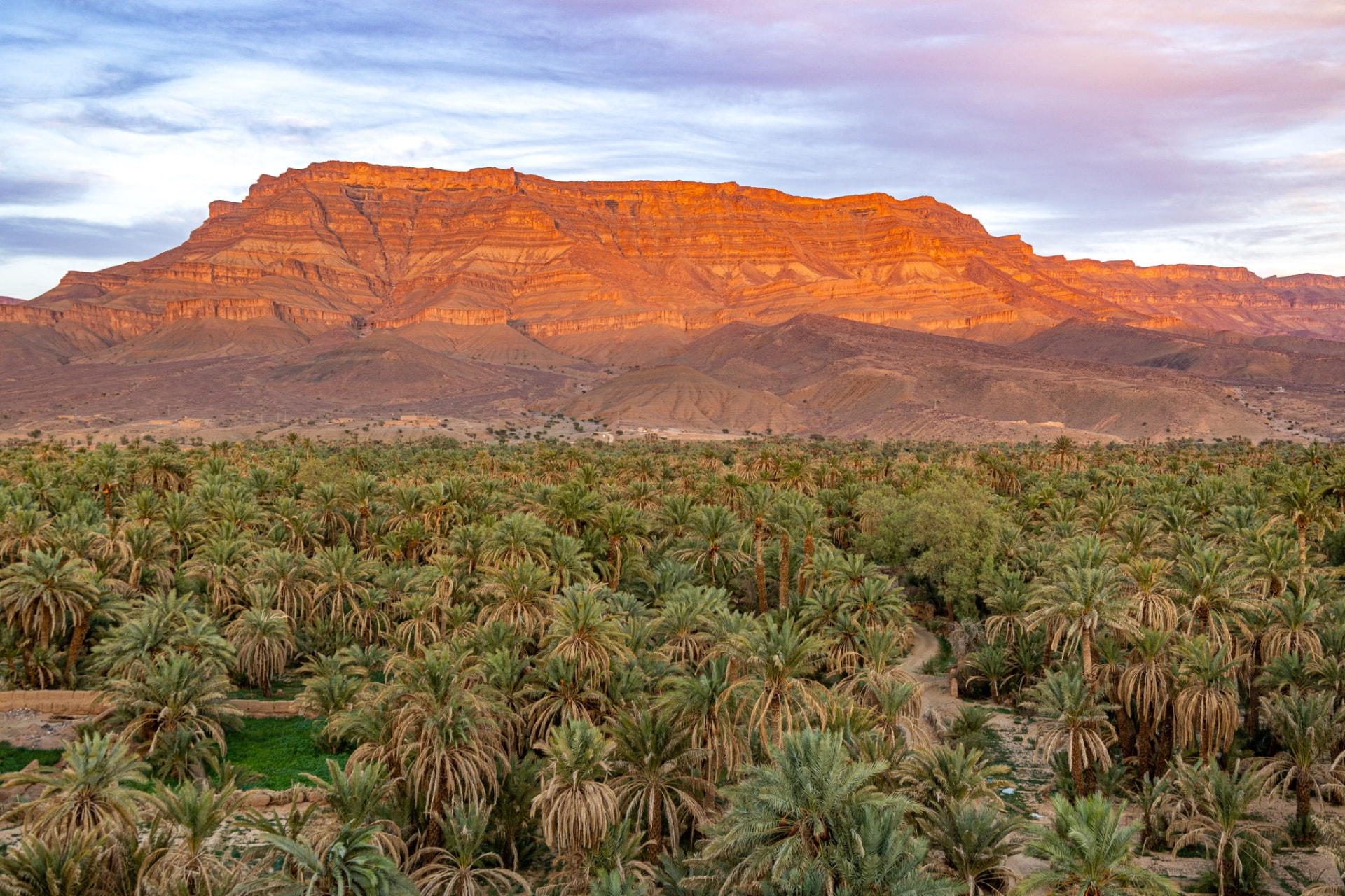
South of the High Atlas, where the mountains give out and the stone plains begin, a river valley runs for well over a hundred kilometres in an almost unbroken ribbon of date palms. The Draa is Morocco's longest river, and along its upper course it supports one of the great oasis systems of North Africa: palm groves, irrigated gardens, fortified villages of earth, and a road that carries you steadily from mountain country into the Sahara.
This guide covers what the Draa actually is, how the route works, what the ksour and kasbahs along it represent, how Zagora and M'Hamid fit in, how the valley differs from the dune fields further out, and the practical layer — driving, pacing, seasons, markets, responsible travel and photography. It avoids naming opening hours, prices or specific site attributions that cannot be verified, because the valley is full of earthen buildings that are easy to misidentify and hard to date.
Geography: why a palm valley exists here
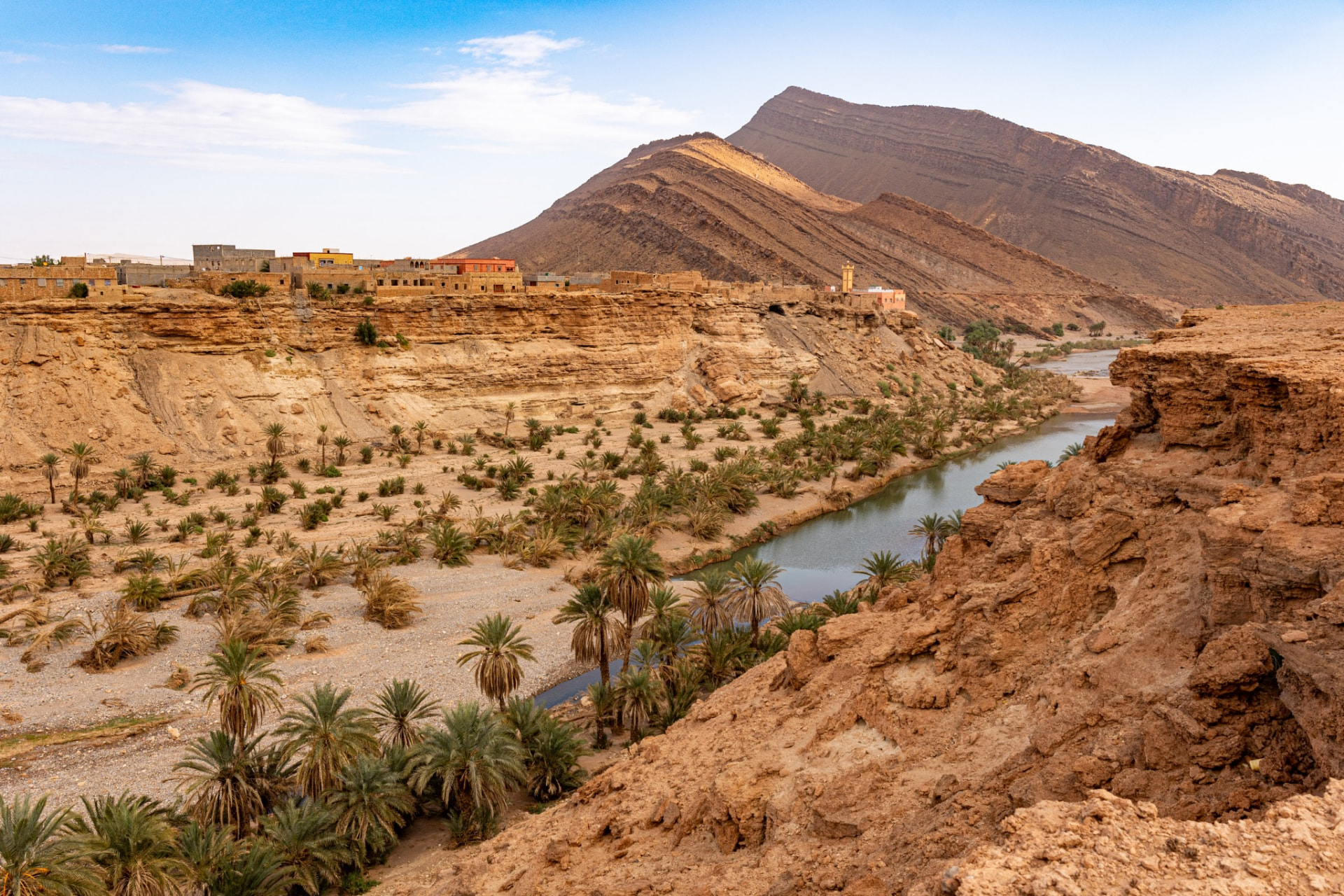
The Draa rises in the High Atlas, gathers water from the mountains, and flows south past Ouarzazate before turning through the gap at Agdz and running south-east towards Zagora and M'Hamid. Beyond that its bed continues west across the desert and reaches the Atlantic only in exceptional years; for practical purposes the "Draa Valley" travellers mean is the green corridor between Agdz and M'Hamid.
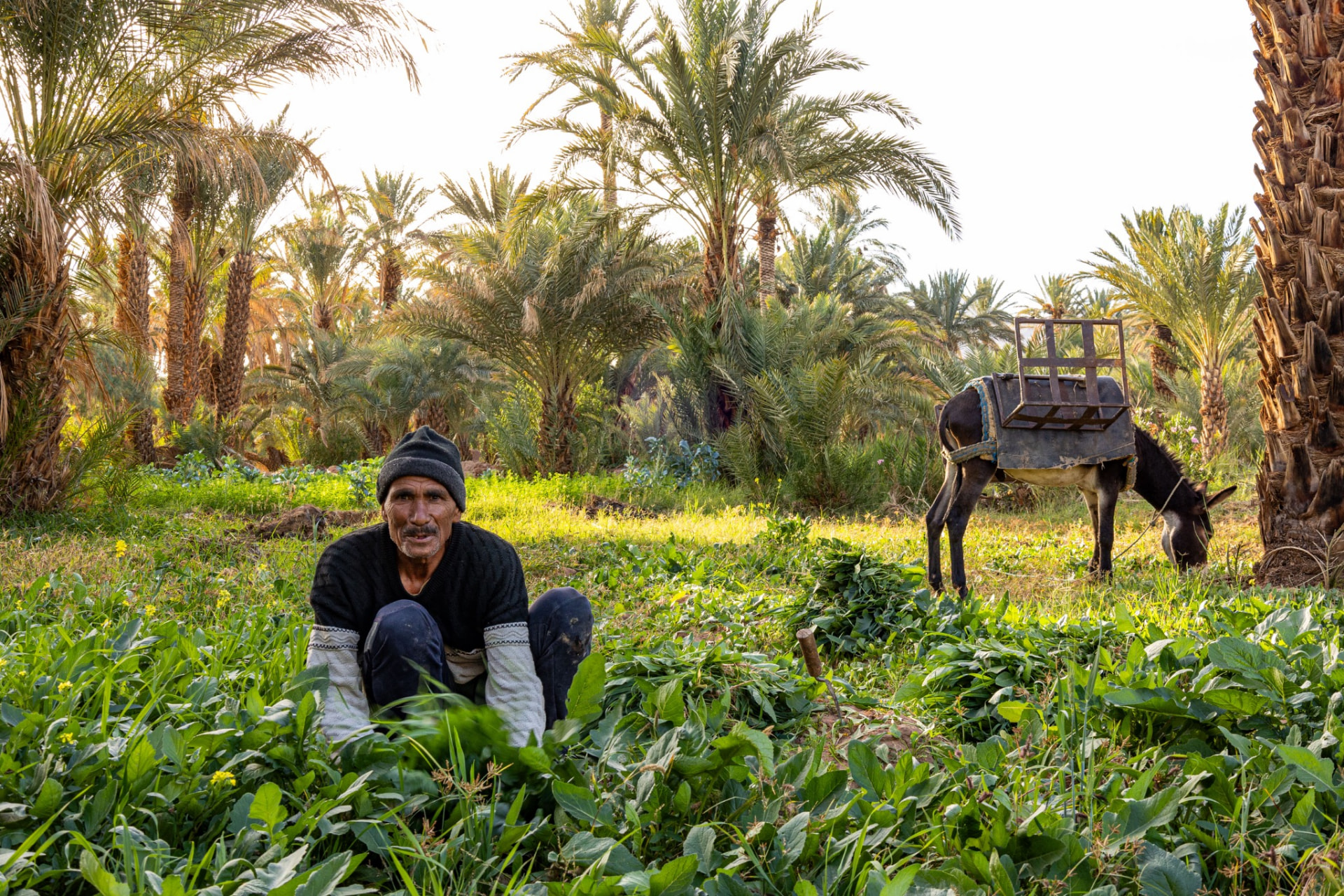
The oasis exists because of that water and because of centuries of management of it. Traditional irrigation channels — seguias — distribute river and groundwater across the valley floor according to long-established rights. The result is a three-layer agriculture that is one of the most efficient systems ever devised for a dry climate: date palms above providing shade, fruit trees and olives beneath them, and cereals, alfalfa and vegetables at ground level. Everything green in the valley is worked land, not wilderness.
The contrast is what makes the drive extraordinary. On one side of the road, dense palm shade and irrigation; a hundred metres away, bare rock and dust running to the horizon.
The route: how the valley is usually travelled
Most journeys reach the Draa from Marrakech over the Tizi n'Tichka pass to Ouarzazate, then south over the Tizi n'Tinififft to Agdz, where the palm belt begins. From Agdz the road follows the valley through a succession of oasis villages towards Zagora, and then on to Tamegroute and M'Hamid, where the tarmac and the palms both end at the desert.
- Marrakech to Agdz is a full day if you travel it properly, with the Atlas crossing and stops.
- Agdz to Zagora is the heart of the valley and should be treated as a half-day at minimum, though it can be driven in far less if you refuse to stop, which would be a waste.
- Zagora to M'Hamid is a shorter run through the last of the palms into increasingly open desert.
The road is sealed and in generally good condition; the constraint is not difficulty but the temptation to treat the valley as a transit corridor to the dunes. Travellers who spend a night in the valley itself, rather than passing through it in a morning, come away with a completely different impression.
Ksour and kasbahs: what you are looking at
The valley is lined with earthen architecture, and the vocabulary is worth getting right.
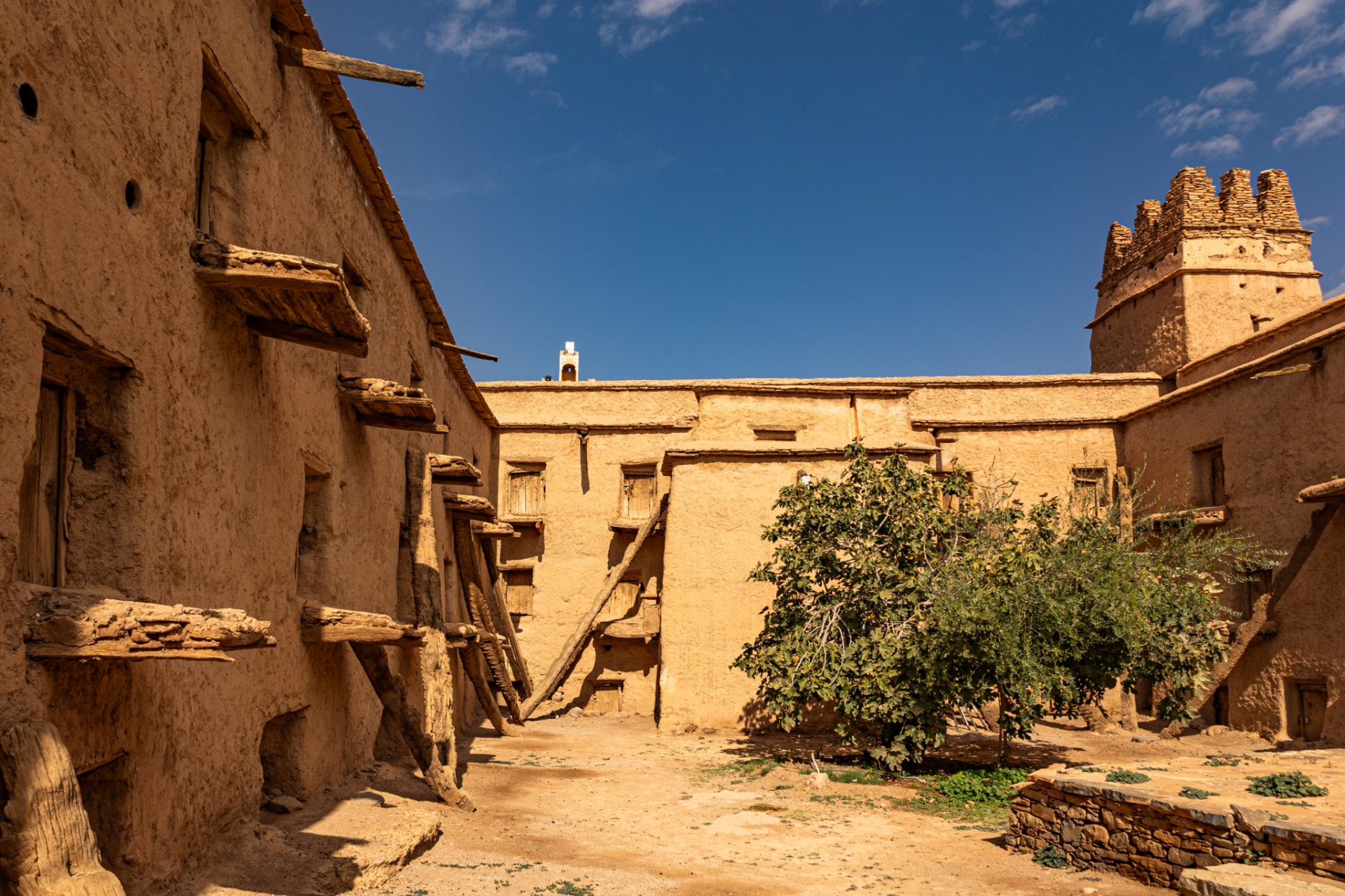
- A ksar (plural ksour) is a fortified village: a walled settlement containing houses, lanes, storage, sometimes a mosque and a communal granary, built as a single defensive unit.
- A kasbah is a fortified residence — typically a single large household or lineage — usually recognisable by corner towers and decorated upper walls.
- Both are built from pisé, rammed earth mixed with straw and sometimes lime, on stone footings.
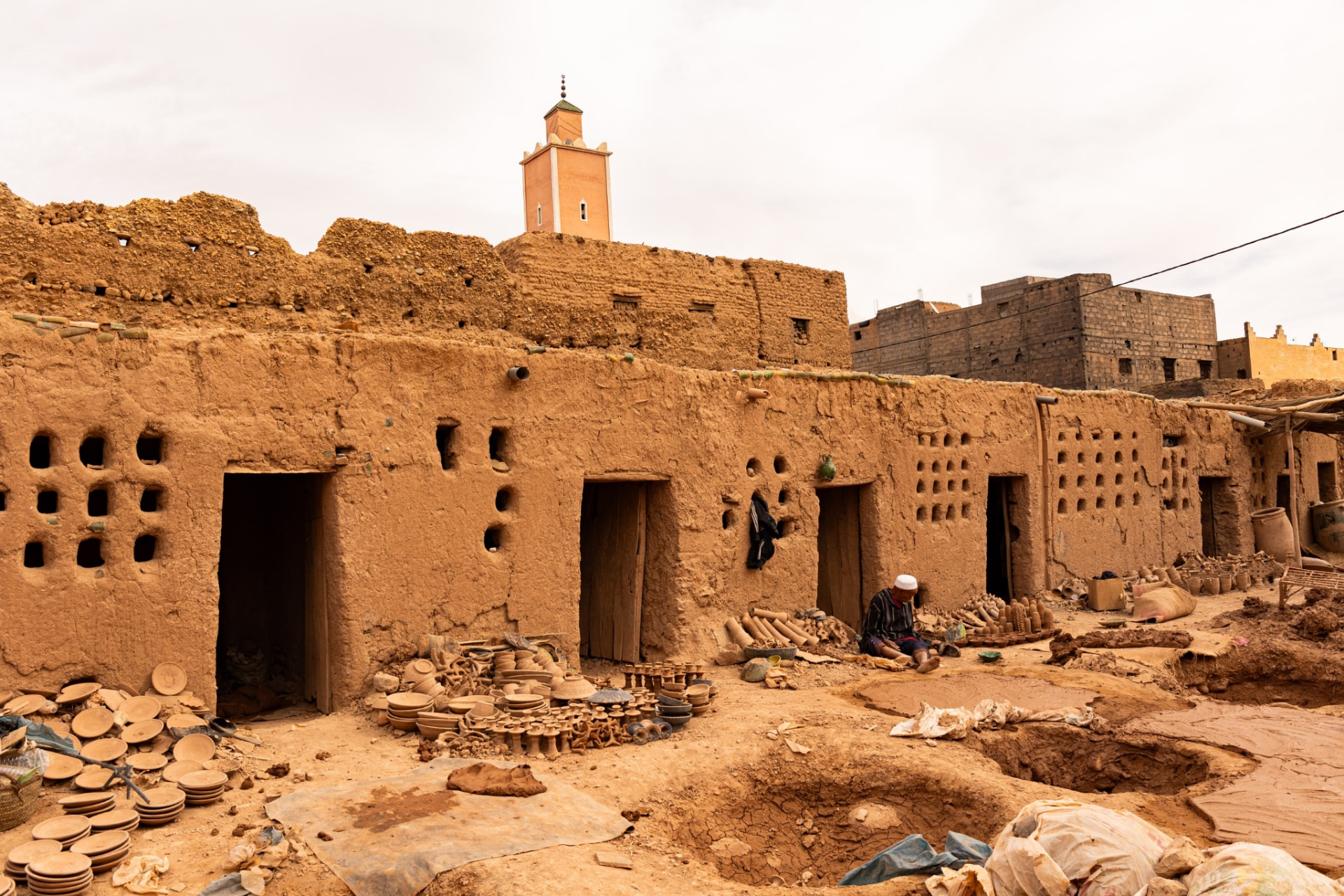
Earthen building is not fragile by nature; it is fragile without maintenance. A wall that is replastered after each rainy season lasts for generations, while a building abandoned for two decades slumps quickly. That is why the valley contains, side by side, ksour that are inhabited and immaculate, ksour half-lived-in, and ksour dissolving back into the ground.
Dating individual structures is genuinely difficult, and confident claims about the age of a particular kasbah should be treated with caution — including on information boards. Repeated repair means a building can be old in plan and recent in fabric at the same time. We prefer to talk about how these buildings worked rather than to attach dates and legends to them, and we would rather say "we do not know" than repeat an attractive story.
Access varies. Some ksour are inhabited private homes, some are partly restored and open with a local guardian, and some are unsafe to enter. Do not assume you may walk in, and do not climb on earthen walls — footfall on a parapet does real damage.
Zagora, Tamegroute and M'Hamid
Zagora is the valley's main town: administrative, functional, a place to resupply, and the site of a well-known weekly market. It is not a picturesque destination in itself, and travellers who arrive expecting an oasis idyll are often surprised. Its value is as a hub and as a working southern Moroccan town.
Tamegroute, south of Zagora, is known for two quite different things: a historic religious centre with a library holding old manuscripts, and a long-standing pottery tradition producing distinctive green-glazed ware fired in underground kilns. Both are genuinely interesting and both depend on who is present and what is open on the day, so treat them as opportunities rather than fixtures.
M'Hamid is where the road ends. It is the last settlement before the open desert, the departure point for Erg Chigaga, and a town shaped by the retreat of the palm belt and by sand encroachment. From here onwards, travel is off-road.
Draa, Erg Chebbi, Erg Chigaga: three different things
These get confused constantly, so to be plain:
- The Draa Valley is an oasis corridor — palms, villages, agriculture and earthen architecture. It is not a dune landscape, and the small dunes near Zagora are not the Sahara most people are imagining.
- Erg Chigaga is a large, remote dune field reached by several hours of off-road driving from M'Hamid, at the far end of the Draa route. It is the natural desert destination for a Draa journey.
- Erg Chebbi is the dune field near Merzouga, in a different part of southern Morocco, reached on sealed roads via the Dades and Todra side of the country — not via the Draa.
So a Draa itinerary pairs naturally with Erg Chigaga, and a Dades–Todra itinerary pairs naturally with Erg Chebbi. Our comparison guide sets out the differences in detail, and the Sahara collection includes both approaches, including the five-day Erg Chigaga route that runs down the valley.
Driving and pacing
The valley rewards a slow itinerary more than almost anywhere else in southern Morocco, because its interest is cumulative rather than concentrated in single sights.
- Allow at least one night in the valley itself, ideally in a restored ksar or kasbah guest house between Agdz and Zagora.
- Plan stops rather than viewpoints: a walk into a palm grove with someone who farms it teaches more than any photograph from the roadside.
- Start early. Morning light in the valley is far better than midday, and the working day begins early too.
- Do not attempt Marrakech to M'Hamid in one day. It is technically possible and thoroughly unpleasant.
- Fuel in the towns, not between them, and carry water for the whole day.
- Watch for livestock, cyclists, pedestrians and unlit vehicles at dusk; night driving on rural roads is best avoided.
Seasons
- Autumn brings comfortable temperatures and the date harvest, which transforms the valley's atmosphere — ladders in the palms, sorting, markets and trade.
- Winter gives bright, clear days and cold nights; excellent for travel, but bring proper layers for desert evenings.
- Spring is green, warm and one of the best windows, though it warms up quickly by late spring.
- Summer is genuinely severe. Travel is possible with early starts and long midday rests, but a summer Draa itinerary should be designed differently from an autumn one.
Wind and dust can occur in any season, particularly around seasonal transitions, and occasional heavy rain can cause flash flooding in a valley system built to shed water quickly. See the national seasonal guide for the wider picture.
Villages, markets and everyday life
The valley's population is mixed — Amazigh, Arab and Haratine communities with long and complex histories, and a long-standing connection to trans-Saharan trade. Weekly souks rotate between towns and are the best single opportunity to see the valley functioning: livestock, dates, vegetables, tools, textiles, tea and conversation. Ask locally which day falls where, since these are fixed traditions but not published schedules, and build the route around one if you can.
Dates are the valley's signature crop and its economy in miniature — dozens of varieties, sorted and priced with great precision. Buying directly from growers or from a cooperative is one of the more useful things a visitor can do here.
The valley also faces real pressures: water scarcity, groundwater depletion, palm disease, sand encroachment and outward migration of young people. Its green ribbon is not a permanent feature of the landscape; it is maintained, and its maintenance is getting harder.
Responsible travel in the Draa
- Water. Use it as if it were scarce, because it is. This is the single most meaningful thing a visitor controls.
- Stay in the valley, not only at its endpoints, so that income reaches oasis villages rather than only the desert camps.
- Buy locally — dates, pottery, textiles — and pay fairly rather than grinding down a price that is already low.
- Respect the gardens. Irrigated plots are private property and channels are easily damaged; walk with someone who knows the paths.
- Do not enter ksour uninvited or climb earthen walls.
- Do not give money or sweets to children. Support a school or association instead if you want to help.
- Camel riding is optional on all our journeys, and we use a 4x4 alternative wherever guests prefer.
- Carry out your rubbish from anywhere without collection.
Photography
The Draa is a difficult and rewarding place to photograph. Midday flattens it completely; early morning and late afternoon give the earthen walls their colour and the palms their depth. Shoot from within the groves as well as above them — the layered agriculture is the story, and it is invisible from a viewpoint. Dust is a constant threat to sensors and lenses, so change lenses as little as possible and carry a blower.
The usual rule applies more strictly in small villages than in cities: ask before photographing people, do not photograph inside homes or private gardens, and treat drone use as restricted unless you have clear local permission. A picture of someone's house is not the same as a picture of a monument.
Combining the Draa with the rest of Morocco
The valley is a component, not a destination in isolation. The combinations that work best:
- Marrakech → Atlas → Draa → Erg Chigaga → return via Foum Zguid or the Tizi n'Test. A loop with little backtracking and a strong narrative from mountain to oasis to dune. See our Sahara journeys.
- Draa plus the Anti-Atlas. Continue west from Foum Zguid towards Tata and the granary country around Aït Kine and Amtoudi — a very quiet route described in our guide to off-the-beaten-track Morocco.
- Draa plus the coast. Exit the south towards Agadir and the Atlantic coast for a complete change of climate and pace.
- Full-country journeys. The valley slots into longer routes in our signature journeys collection, usually with two nights in or near the oasis.
Frequently asked questions
How long does the Draa Valley take to drive?
Agdz to Zagora is a straightforward half-day with stops, and Zagora to M'Hamid is shorter again. The question is not how fast it can be driven but how much you stop; a day and a night in the valley is a realistic minimum.
Is the Draa Valley the Sahara?
No. It is an oasis corridor leading to the Sahara. The dunes most people picture are at Erg Chigaga, beyond M'Hamid, or at Erg Chebbi in a different region entirely.
Can I visit the kasbahs and ksour?
Some, with a local guardian or guide. Others are inhabited private homes or structurally unsafe. Access varies and cannot be guaranteed in advance.
Is Zagora worth staying in?
It is useful rather than beautiful. Many travellers prefer a night in the palm groves between Agdz and Zagora, using the town for supplies and its market.
When is the date harvest?
Autumn, with timing varying by variety, altitude and year. It is a wonderful time to be in the valley, but exact dates cannot be fixed in advance.
Do I need a 4x4?
Not for the valley road itself, which is sealed. Yes for the desert beyond M'Hamid, where off-road driving with an experienced driver is essential.
Is it suitable for families?
Yes, with sensible pacing. Palm-grove walks, pottery, markets and a desert night usually work very well for children; the constraints are heat and driving distance.